| Address | Phu My Town, Tan Thanh Dist., Ba Ria – Vung Tau Province |
| Province | Ho Chi Minh City |
| Developer | URBAN AND INDUSTRIAL ZONE DEVELOPMENT INVESTMENT CORPORATION. |
| Total area | 621 ha |
| Free land | 373 ha |
| GPS | 10.558792, 107.050858 |
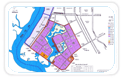
Located in West-Southern of Phu My new urban:
- Adjacent to Phu My 1 IZ in the North;
- Adjacent to National Highway No.51 in the East;
- Adjacent to Cai Mep IZ in the South;
- Adjacent to BaSon Shipyard and PhuMy Port in the West.
- Main road D3, length 1,443.14m, cross-section 63m, lane for cars 24m, separator 3m.
- Main road N6, length 1,410m, cross-section 31m, lane for cars 15m.
- Others are 02 lanes, width 8m.
Substation with capacity is 110/22kv - 103MVA supplying chiefly power to production factories in industrial zone.
From Phu My underground water plant with capacity of 20,000 m3 per day; assure to supply cleaned water to the fence of factories continuously 24hours/day.
+ Capacity in the 1st stage: 4.000m3/day
Sufficient telecommunication network assuring the convenient telecomunication in domestic and international calls.
- High above sea level : about 2.7 m.
- Average humidity : 70% - 85%.
- Average temperature : 29-32 0 C,
- Average annual rainfall : 1,606mm